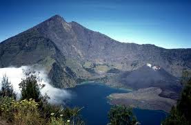
Mount Rinjani is a mountain located on the island of Lombok, West Nusa Tenggara. Mountain which is the second highest volcano in Indonesia with an altitude of 3726 m above sea level and is located at latitude 8 º 25 'S and 116 º 28' E is a favorite for mountain climbers Indonesia because of the beauty of the landscape. This mountain is part of the Mount Rinjani National Park has an area of approximately 41 330 ha and will be proposed the addition to be 76 000 ha to the west and east.
Administratively, the mountain is located in the territory of three districts: East Lombok, Central Lombok and West Lombok.
Topography
Mount Rinjani with the highest point 3726 m above sea level, dominating most of the views of the northern island of Lombok.
In the west there Rinjani caldera cone with an area of approximately 3500 m × 4800 m, extending west to the east you. In this there is Segara Anak caldera (soon = sea, lake) covering 11 million square meters with a depth of 230 m. The water that flows from this lake to form a very beautiful waterfall, flowing through a steep ravine. At Segara Anak many carp and tilapia are so often used for fishing. The southern part of the lake is called Segara Endut.
On the east side of the caldera there are New Mount (or Mount Barujari) which has a crater measuring 170m x 200 m with a height of 2296-2376 m above sea level. This small mountain last active / erupted from the date of May 2, 2009 and throughout May, having previously also erupted in the 2004 eruption 2004.Jika no casualties, the 2009 eruption has indirectly claimed the lives of 31 people, a flash flood on the crowing (River) Tanggek urging of lava into the Segara Anak. Previously, Mount Barujari ever recorded erupted in 1944 (and establishment), 1966, and 1994.
In addition to the crater of Mount Barujari there are also others who have erupted, called Mount Group.
Ascent
Mount Rinjani is located on the island of Lombok, Mount Rinjani To go, you can use the direct bus from Jakarta to Mataram, Mataram after you get to the village Sembalun or can also use the vehicle to the village Senaru setempat.atau using flight from Jakarta, Surabaya and Denpasar heading to the airport Selaparang Mataram - Lombok.
Rinjani has panaroma best among the mountains in Indonesia. Each year (June-August) visited nature lovers from local residents, students, nature lovers.
Temperatures average around 20 ° C; the lowest 12 ° C. Strong winds are common at the peak in August.
In addition to the peak, the haunt is Segara Anakan, a lake situated at an altitude of 2.000m above sea level. To reach this location we can climb from the village Senaru or Sembalun Lawang village (two nearest entry point at an altitude of 600m asl and 1.150m above sea level).
Most climbers start climbing from the climbing route and end at Sembalun Senaru, it can save 700m altitude. Sembalun route is rather long but flat, and the weather is hotter because it is through the scorching savannas (cold temperatures, but direct solar radiation burning the skin). cream shading is highly recommended.
The route climbs from Senaru without pause, but due to weather gently through the forest. From both locations takes about 7 hours walking toward the ridge at an altitude of 2.641m lips asl (arrived at Plawangan Senaru or Plawangan Sembalun). In this place overlooking the lake, or to the outside is very nice. Of Plawangan Senaru (if it rises from the Senaru) down to the lake via a steep wall to a height of 2000 meters above sea level) that can be taken within 2 hours. We can camp on the lake, fishing (Carper, Oreochromis mossambicus) are aplenty. Lombok residents have been to immediately seedling tradition to soak in hot tubs and fishing.
To reach the top (of the lake) have to walk up the west wall and climb the 700m-high ridge height 1.000m to be taken within 2 hours of stage 3 and 4 hours. The first stage towards Plawangan Sembalun, last camp to wait for the morning. Summit usual attack at 3 am to find the beautiful moments - the sun rises at the top of Rinjani.
The journey to the summit quite tolerable; for climbing on the lip of the crater with a margin of safety is mediocre. Terrain of sand, rock, soil. Last 200 meters of altitude must be taken with great difficulty, because one step forward followed by a half step down (sink rock gravel). For the highlander - is the most challenging and unpaid preferred because of the rough terrain with beautiful natural scenery. Mount Agung in Bali, Mount Ijen-Merapi in Banyuwangi and Mount Tambora in Sumbawa clearly visible when the weather is nice in the morning. Not necessary to climb Rinjani tools, enough stamina, patience and "passion".
The whole trip can be achieved in the program three days and two nights, or if you want to see two other objects: Cave New Finger Milk and mountain (Mount Rinjani child with a new crater in the middle of the lake) need an additional two days' journey. Logistical preparation is necessary, but fortunately everything to be gained in a nearby village. Tent, sleeping bag, eating utensils, food and whatever is needed (including radio communications) can be rented from the homestay, homestay in the village that flourished Senaru.
